Bishop Wilton Wold on:
[Wikipedia]
[Google]
[Amazon]
Bishop Wilton Wold is the highest point of the
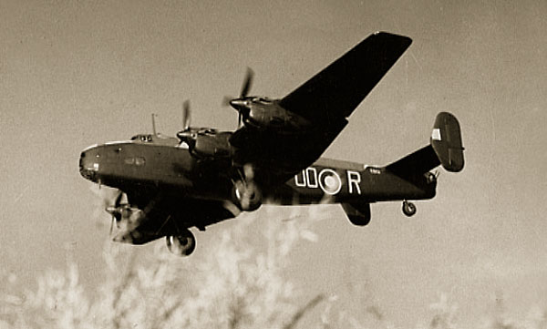
 Around 10 am on 7 February 1944 a Halifax MkV DK192 (OO-N) from 1663 HCU based at
Hockney's painting ''Garrowby Hill''
Marilyns of England Landforms of the East Riding of Yorkshire Highest points of English counties Yorkshire Wolds Aviation accidents and incidents locations in England {{EastRiding-geo-stub
Yorkshire Wolds
The Yorkshire Wolds are low hills in the counties of the East Riding of Yorkshire and North Yorkshire in north-eastern England. The name also applies to the district in which the hills lie.
On the western edge, the Wolds rise to an escarpment wh ...
in the East Riding of Yorkshire
The East Riding of Yorkshire, or simply East Riding or East Yorkshire, is a ceremonial county and unitary authority area in the Yorkshire and the Humber region of England. It borders North Yorkshire to the north and west, South Yorkshire to t ...
, England
England is a country that is part of the United Kingdom. It shares land borders with Wales to its west and Scotland to its north. The Irish Sea lies northwest and the Celtic Sea to the southwest. It is separated from continental Europe b ...
. The summit, known as Garrowby Hill, lies about north of Pocklington
Pocklington is a market town and civil parish situated at the foot of the Yorkshire Wolds in the East Riding of Yorkshire, England. The 2011 Census recorded its population as 8,337. It is east of York and northwest of Hull.
The town's sk ...
.
As with most of the wolds, it is wide, flat and agricultural in nature. The A166 road
The A166 road is a trunk road between the outskirts of York and Driffield in the historic county of Yorkshire. The road used to terminate at the seaside town of Bridlington, until the opening of the Driffield by-pass caused the final section ...
passes right by the top. However it is a Marilyn (having topographic prominence
In topography, prominence (also referred to as autonomous height, relative height, and shoulder drop in US English, and drop or relative height in British English) measures the height of a mountain or hill's summit relative to the lowest contou ...
of at least ). There is a trig point
A triangulation station, also known as a trigonometrical point, and sometimes informally as a trig, is a fixed surveying station, used in geodetic surveying and other surveying projects in its vicinity. The nomenclature varies regionally: they a ...
, two covered reservoirs
A reservoir (; from French ''réservoir'' ) is an enlarged lake behind a dam. Such a dam may be either artificial, built to store fresh water or it may be a natural formation.
Reservoirs can be created in a number of ways, including control ...
and an aerial.
The British
British may refer to:
Peoples, culture, and language
* British people, nationals or natives of the United Kingdom, British Overseas Territories, and Crown Dependencies.
** Britishness, the British identity and common culture
* British English, ...
artist David Hockney
David Hockney (born 9 July 1937) is an English painter, draftsman, printmaker, stage designer, and photographer. As an important contributor to the pop art movement of the 1960s, he is considered one of the most influential British artists o ...
painted the view from the summit in 1998.
Halifax bomber crash 1944
 Around 10 am on 7 February 1944 a Halifax MkV DK192 (OO-N) from 1663 HCU based at
 RAF Rufforth
Royal Air Force Rufforth or RAF Rufforth is a former Royal Air Force station located near Rufforth in North Yorkshire, England. It was used by only one operational squadron on long-range bombing missions during the Second World War, with most f ...
crashed on Garrowby Hill.
As well as the 7 aircrew who were on a training flight, a passing lorry driver was also killed.
There is a memorial in a layby on the A166 at Garrowby Hill

David Hockney
Yorkshire-born artistDavid Hockney
David Hockney (born 9 July 1937) is an English painter, draftsman, printmaker, stage designer, and photographer. As an important contributor to the pop art movement of the 1960s, he is considered one of the most influential British artists o ...
produced a painting of Garrowby Hill in 1998.
References
External links
Hockney's painting ''Garrowby Hill''
Marilyns of England Landforms of the East Riding of Yorkshire Highest points of English counties Yorkshire Wolds Aviation accidents and incidents locations in England {{EastRiding-geo-stub